The Digital Walters is a branch of The Walters Art Museum Manuscripts Department.
The Digital Walters is a branch of The Walters Art Museum Manuscripts Department.

Originally composed in 932 AH / 1525 CE and dedicated to Sultan Süleyman I (the Magnificent), this great work by Piri Reis (d. 962 AH / 1555 CE) on navigation was later revised and expanded. The present manuscript, made mostly in the late eleventh century AH / seventeenth CE, is based on the later expanded version and has some 240 exquisitely executed maps and portolan charts. They include a world map with the outline of the Americas (fol. 41a) and maps of coastlines (bays, capes, peninsulas); islands; mountains; and cities of the Mediterranean basin and the Black Sea. The work starts with a description of the coastline of Anatolia and the islands of the Aegean Sea, the Peloponnese peninsula, and the eastern and western coasts of the Adriatic Sea. It then proceeds to describe the western shores of Italy, southern France, Spain, North Africa, Palestine, Israel, Lebanon, Syria, western Anatolia, various islands north of Crete, the Sea of Marmara, the Bosporus, and the Black Sea. It ends with a map of the shores of the Caspian Sea (fol. 374a).
Written in clear, vocalized naskh script, mostly in black, with rubricated chapter headings
Principal cataloger: Gacek, Adam
Cataloger: Landau, Amy
Cataloger: Smith, Sita
Editor: Bockrath, Diane
Contributor: Barrera, Christina
Contributor: Emery, Doug
Contributor: Herbert, Lynley
Contributor: Noel, William
Contributor: Simpson, Shreve
Contributor: Tabritha, Ariel
Contributor: Toth, Michael B.
Contributor: Valle, Chiara
Conservator: Jewell, Stephanie
Conservator: Quandt, Abigail
Goodrich, Thomas D. "Supplemental Maps in the Kitab-i Bahriye of Piri Reis." Archivum Ottomanicum 13 (1993-94): 117-141.
Soucek, Svatopluk. Piri Reis and Turkish Mapmaking after Columbus: The Khalili Portolan Atlas. London: Nour Foundation in association with Azimuth Editions and Oxford University Press, 1996.
Loupis, Dimitris. “Ottoman Adaptations of Early Italian Isolarii.” Journal of the International Map Collectors’ Society 80 (2000): 15-23.
Loupis, Dimitris. “Ottoman Nautical Charting and Miniature Painting: Technology and Aesthetics.” In M. Uğur Derman 65th Birthday Festschrift / 65 Yaş Armağanı, ed. İrvin Cemil Schick (İstanbul: Sabancı Üniversitesi, 2000), 369-397.
Loupis, Dimitris. “Piri Reis’s Book on Navigation as a Geography Handbook: Ottoman Efforts to Produce an Atlas during the Reign of Sultan Mehmed IV (1648-1687).” The Portolan: Journal of the Washington Map Society 52 (2001-2002): 11-17.
Hepworth, Paul. "Production and Date of the Walters' Kitab-i Bahriye." Journal of the Walters Art Museum 63 (2005): 73-80.
These are pages that we pulled aside that disrupted the flow of the manuscript reader. These may be bindings, inserts, bookmarks, and various other oddities.


Turkey
Late 11th century AH / 17th CE -- early 12th century AH / 18th CE
book
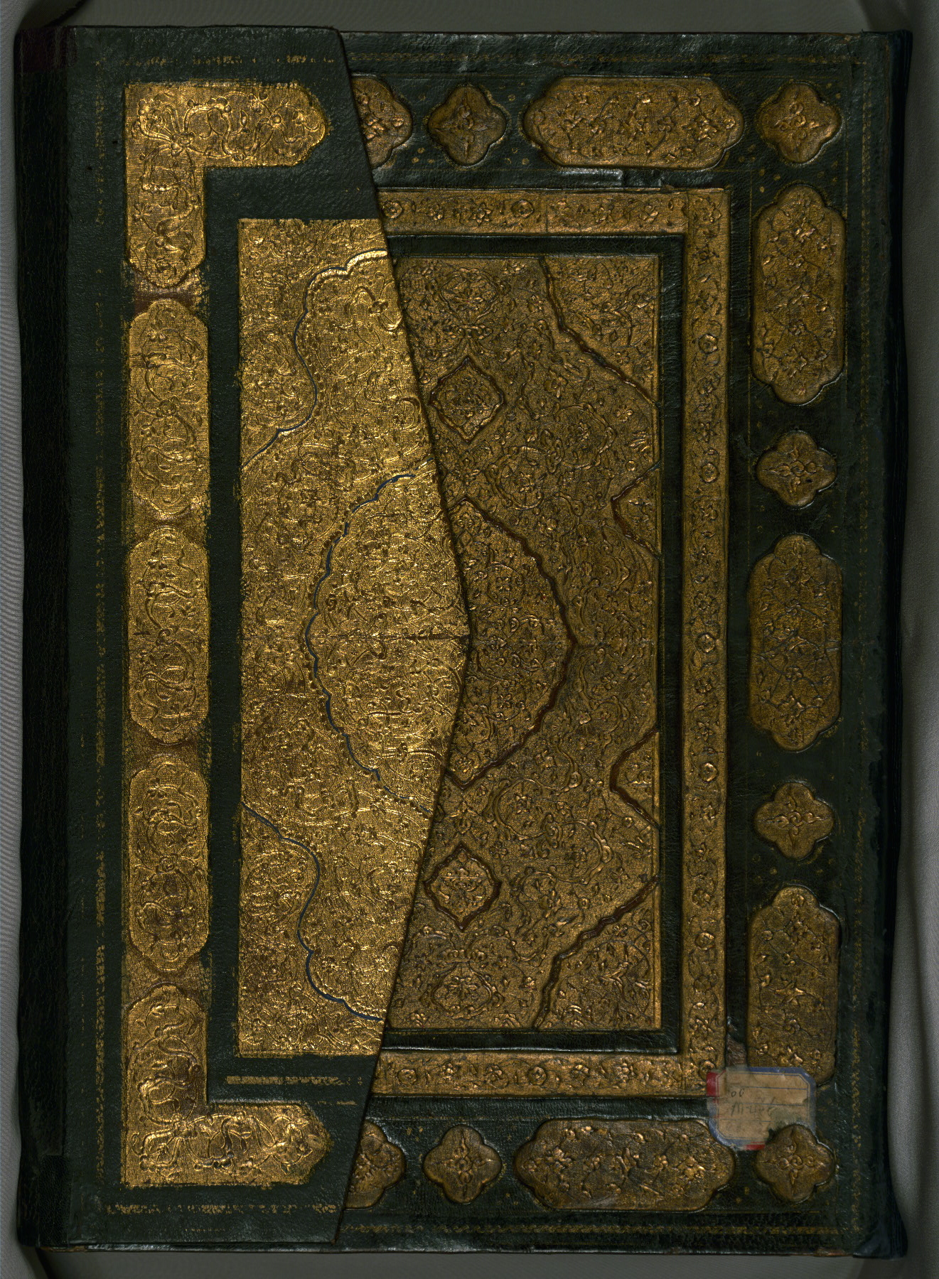
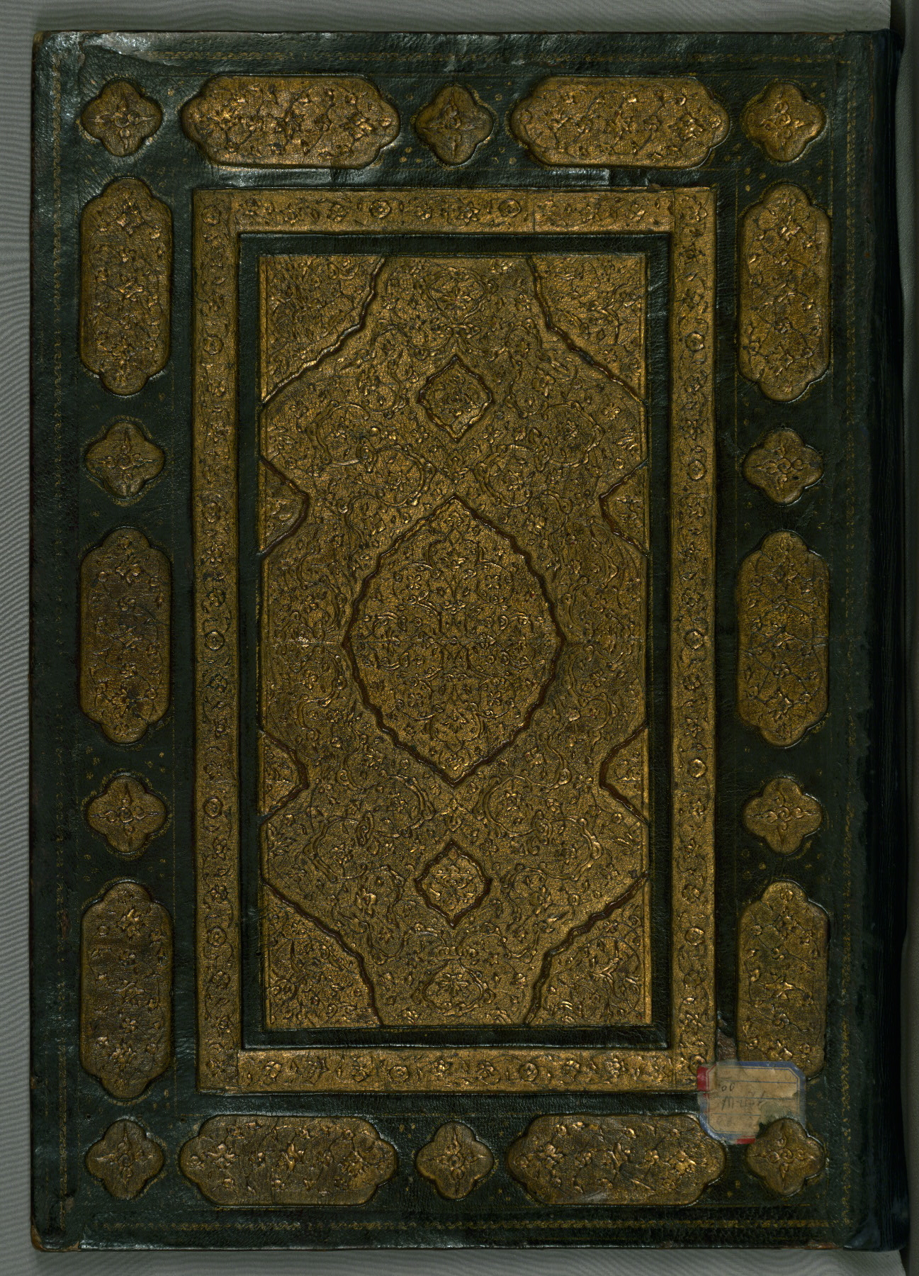
Non-original Binding
Later binding, slightly too large for the textblock (with flap); central panel and side panels richly decorated and brushed with gold; dentelle-style doublures of red leather with a central lobed oval and cornerpieces with filigree work
The primary language in this manuscript is Turkish, Ottoman (1500-1928).
Name: Aḥmad Afandī
Name: ʿAlī Afandī
Name: Sayyid ʿAlī Qapūdān
Bequest
Walters Art Museum, 1931, by Henry Walters bequest
Turkey
Late 11th century AH / 17th CE -- early 12th century AH / 18th CE
book
The primary language in this manuscript is Turkish, Ottoman (1500-1928).
Name: Aḥmad Afandī
Name: ʿAlī Afandī
Name: Sayyid ʿAlī Qapūdān
Bequest
Walters Art Museum, 1931, by Henry Walters bequest
Originally composed in 932 AH / 1525 CE and dedicated to Sultan Süleyman I (the Magnificent), this great work by Piri Reis (d. 962 AH / 1555 CE) on navigation was later revised and expanded. The present manuscript, made mostly in the late eleventh century AH / seventeenth CE, is based on the later expanded version and has some 240 exquisitely executed maps and portolan charts. They include a world map with the outline of the Americas (fol. 41a) and maps of coastlines (bays, capes, peninsulas); islands; mountains; and cities of the Mediterranean basin and the Black Sea. The work starts with a description of the coastline of Anatolia and the islands of the Aegean Sea, the Peloponnese peninsula, and the eastern and western coasts of the Adriatic Sea. It then proceeds to describe the western shores of Italy, southern France, Spain, North Africa, Palestine, Israel, Lebanon, Syria, western Anatolia, various islands north of Crete, the Sea of Marmara, the Bosporus, and the Black Sea. It ends with a map of the shores of the Caspian Sea (fol. 374a).
Written in clear, vocalized naskh script, mostly in black, with rubricated chapter headings
Principal cataloger: Gacek, Adam
Cataloger: Landau, Amy
Cataloger: Smith, Sita
Editor: Bockrath, Diane
Contributor: Barrera, Christina
Contributor: Emery, Doug
Contributor: Herbert, Lynley
Contributor: Noel, William
Contributor: Simpson, Shreve
Contributor: Tabritha, Ariel
Contributor: Toth, Michael B.
Contributor: Valle, Chiara
Conservator: Jewell, Stephanie
Conservator: Quandt, Abigail
Goodrich, Thomas D. "Supplemental Maps in the Kitab-i Bahriye of Piri Reis." Archivum Ottomanicum 13 (1993-94): 117-141.
Soucek, Svatopluk. Piri Reis and Turkish Mapmaking after Columbus: The Khalili Portolan Atlas. London: Nour Foundation in association with Azimuth Editions and Oxford University Press, 1996.
Loupis, Dimitris. “Ottoman Adaptations of Early Italian Isolarii.” Journal of the International Map Collectors’ Society 80 (2000): 15-23.
Loupis, Dimitris. “Ottoman Nautical Charting and Miniature Painting: Technology and Aesthetics.” In M. Uğur Derman 65th Birthday Festschrift / 65 Yaş Armağanı, ed. İrvin Cemil Schick (İstanbul: Sabancı Üniversitesi, 2000), 369-397.
Loupis, Dimitris. “Piri Reis’s Book on Navigation as a Geography Handbook: Ottoman Efforts to Produce an Atlas during the Reign of Sultan Mehmed IV (1648-1687).” The Portolan: Journal of the Washington Map Society 52 (2001-2002): 11-17.
Hepworth, Paul. "Production and Date of the Walters' Kitab-i Bahriye." Journal of the Walters Art Museum 63 (2005): 73-80.
These are pages that we pulled aside that disrupted the flow of the manuscript reader. These may be bindings, inserts, bookmarks, and various other oddities.
Clear All